Make Industrial-Grade Photogrammetry Solution Available for Everyone !
Introducing MipMap
MipMap Indestry Solution
2D&3D Reconstruction Output with Just One Click
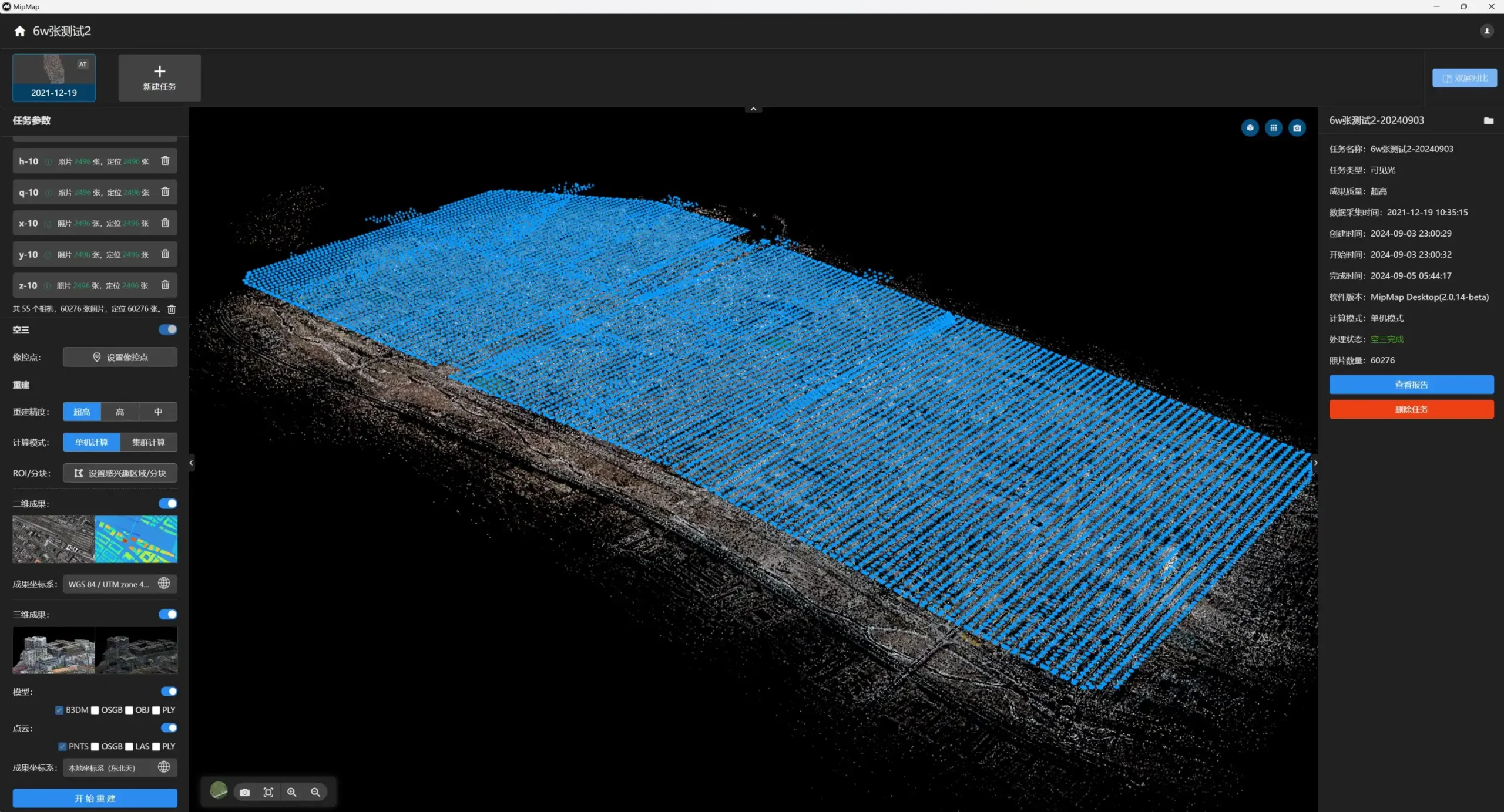
City Scale Aerial Triangulation With Limited Resource

Processing 60276 images with 16GB free RAM
Ultra Fast Process Speed
Reconstruction 60276 images
DOM/DSM Generate XX miniutes
Textured Mesh Generate XX miniutes
Seamless Adapt to DJI Drones
XXXXX
Features For Professional Drone Mapping
Custom Camera Group and Param Setting
Georeffence Constrain
Georefence Constrain
- Custom Georefence Pos Constrain which make center meter accuracy possiable
- automaticly adapt to DJI images
- Ground Control Point Constrain
Custom Coordinate System
Massive Format Support
| Output Type | Non LOD Format | LOD Format |
|---|---|---|
| 2D Map | GeoTiff | Google Map Tiles(256*256) |
| 3D Mesh | OBJ, PLY | 3D Tiles(B3DM), OSGB |
| 3D Point Cloud | PLY, LAS/LAZ,PCD | 3D Tiles(PNTS) |
| Measurement Vector |
Hello world!
Welcome to WordPress. This is your first post. Edit or delete it, then start writing!
Drone Mapping Blogs
As-Constructed Survey | Sequen Tasks within Project
As-Constructed Survey | Labeling and Measureing Report to Cooperation
AS-Designed&AS-Built Survey | AutoCAD .dwg Overlay
Hello world!
Welcome to WordPress. This is your first post. Edit or delete it, then start writing!
AEC Industry Blogs
Automate your business
What our user say about MipMap
“3D reconstruction using photogrammetry technology demonstrates remarkable capabilities in generating high-fidelity models. However, the prohibitive software costs and extensive data processing requirements remain significant barriers for widespread adoption. Notably, the textured mesh generation feature integrated with Mipmap technology achieves unprecedented efficiency , it accelerates processing by 3-5× while maintaining centimeter accuracy. Furthermore, the flexible subscription model (starting at $29.9/month) significantly lowers entry thresholds, thereby enabling researchers and small studios to leverage this cutting-edge technology without substantial upfront investments. “
“Not only is the software cost-effective, but its intuitive interactive design and streamlined usability also reduced training expenses significantly. For instance, just one click to initiate automated processes, thereby allowing staff to focus on core tasks instead of manual interventions. Ultimately, this combination of affordability and operational simplicity delivers both immediate and long-term financial benefits.”
“For me, what stands out most is the hierarchical project management framework, where each project serves as a top-level entry while enabling side by side comparison and analysis of time-series tasks. For instance, I now track construction progress in real time with not just visual timelines but also quantified metrics—unlike fragmented photo-based reports, this system ensures all measurable elements are retained throughout the project lifecycle. Moreover, the platform’s traceable construction records not only prevent data silos but also create an auditable trail for compliance reviews, thereby eliminating gaps in accountability.”